
Analysing the spatial distribution of land surface temperature at Nghi Son Refinery and Petrochemical Complex using Landsat and Sentinel 2 satellite image data
Abstract
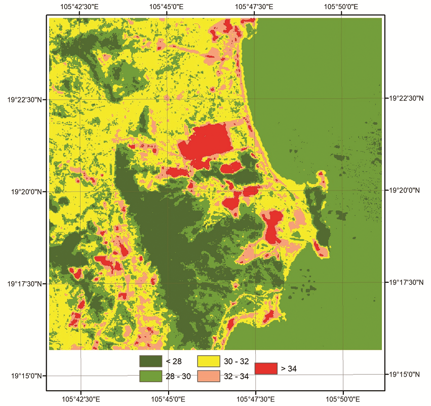
The Landsat 5, Landsat 8 and Sentinel 2A satellite image data are used for extracting land surface temperature, thereby mapping the spatial distribution of land surface temperature at Nghi Son Refinery and Petrochemical Complex. The obtained results then can be used in monitoring land surface temperature changes, for land use planning as well as in minimising the impact of production processes to the environment.
References
Trần Thị Vân, Hoàng Thái Lan và Lê Văn Trung, “Phương pháp viễn thám nhiệt trong nghiên cứu phân bố nhiệt độ bề mặt đô thị”, Tạp chí các khoa học về trái đất, Số 31, Tập 2, trang 168 - 177, 2009.
Suzana Binti Abu Bakar, Biswajeet Pradhan, Usman Salihu Lay, and Saleh Abdullahi, “Spatial assessment of land surface temperature and land use/land cover in Langkawi Island”, IOP Conferece Series: Earth and Environmental Science, Kuala Lumpur, Malaysia, 13 - 14 April 2016. DOI:10.1088/1755-1315/37/1/012064.
Mukesh Singh Boori, Vit Vozenílek, Heiko Balter, and Komal Choudhary, “Land surface temperature with land cover classes in Aster and Landsat data”, Journal of Remote Sensing & GIS, Vol. 4, No. 1, pp. 1 - 4, 2015. DOI:10.4172/2169-0049.1000138.
Subhanil Guha, Himanshu Govil, Anindita Dey, and Neetu Gill, “Analytical study of land surface temperature with NDVI and NDBI using Landsat 8 OLI and TIRS data in Florence and Naples city, Italy”, European Journal of Remote Sensing, Vol. 51, No. 1, pp. 667 - 678, 2018. DOI: 10.1080/22797254.2018.1474494.
H.M. Imran, Anwar Hossain, A.K.M. Saiful Islam, Ataur Rahman, Md Abul Ehsan Bhuiyan, Supria Paul, and Akramul Alam, “Impact of land cover changes on land surface temperature and human thermal comfort in Dhaka city of Bangladesh”, Earth Systems and Environment, Vol. 5, pp. 667 - 693, 2021. DOI: 10.1007/s41748-021-00243-4.
[Swades Pal and Sk. Ziaul, “Detection of land use and land cover change and land surface temperature in English Bazar urban centre”, The Egyptian Journal of Remote Sensing and Space Science, Vol. 20, No. 1, pp. 125 - 145, 2017. DOI: 10.1016/j.ejrs.2016.11.003.
Trịnh Lê Hùng, “Nghiên cứu sự phân bố nhiệt độ bề mặt bằng dữ liệu ảnh vệ tinh đa phổ Landsat”, Tạp chí các khoa học về trái đất, Số 36, Tập 1, trang 82 - 89, 2014.
Timo Kumplula, Anu Pajunen, Elina Kaarlejärvi, Bruce C. Forbes, and Florian Stammler “Land use and land cover change in Arctic Russia: Ecological and social implications of industrial development”, Global Environmental Change, Vol. 21, No. 5, pp. 550 - 562, 2011. DOI: 10.1016/j.gloenvcha.2010.12.010.
Timo Kumptula, Bruce C. Forbes, Florian Stammler, and Meschtyb Mysshtyb, “Dynamics of a coupled system: Multi-resolution remote sensing in assessing social-ecological responses during 25 years of gas field development in Arctic Russia”, Remote Sensing, Vol. 4, pp. 1046 - 1068, 2012. DOI: 10.3390/rs4041046.
Qin Yu, Howard E. Epstein, Ryan Engstrom, Nikolay Shiklomanov, and Dmitry Streletskiy, “Land cover and land use changes in the oil and gas regions of Northwestern Siberia under changing climatic conditions”, Environmental Research Letters, Vol. 10, 2015. DOI: 10.1088/1748-9326/10/12/124020.
E.O. Makinde, “Resultant land use and land cover change from oil spillage using remote sensing and GIS”, Research Journal of Applied Sciences, Engineering and Technology, Vol. 6, No. 11, pp. 2032 - 2040, 2013. DOI: 10.19026/rjaset.6.3820.
Yifang Wang, Di Liu, Fushan Zhang, and Qingling Zhang, “Monitoring the spatio-temporal dynamics of shale oil/gas development with Landsat time series: Case studies in the USA”, Remote Sensing, Vol. 14, No. 5, 2022. DOI: 10.3390/rs14051236.
Colm Jordan, Luke Bateson, and Alessandro Novellino, “Environmental baseline monitoring for shale-gas development: Insights for monitoring ground motion using InSAR analysis”, Science of The Total Environment, Vol. 696, 2019. DOI: 10.1016/j.scitotenv.2019.134075.
Yongxue Liu, Chuanmin Hu, Chao Sun, Wenfeng Zhan, Shaojie Sun, Bihua Xu, Yanzhu Dong, “Assessment of offshore oil/gas platform status in the northern Gulf of Mexico using multi-source satellite time-series images”, Remote Sensing of Environment, Vol. 208, pp. 63 - 81, 2018. DOI: 10.1016/j.rse.2018.02.003.
Enric Valor and Vicente Caselles, “Mapping land surface emissivity from NDVI: Application to European African and South American areas”, Remote sensing of Environment, Vol. 57, No. 3, pp. 167 - 184, 1996. DOI: 10.1016/0034-4257(96)00039-9.
J.W. Rouse, R.H. Hass, J.A. Schell, and D.W. Deering, “Monitoring vegetation systems in the Great Plains with ERTS”, 3rd Earth Resources Technology Satellite-1 (ERTS) Symposium, 1973. [Online]. Available: https://ntrs.nasa.gov/citations/19740022614.
Trịnh Lê Hùng, “Kết hợp ảnh vệ tinh Landsat 8 và Sentinel 2 trong nâng cao độ phân giải nhiệt độ bề mặt”, Tạp chí Khoa học Đại học Quốc gia Hà Nội: Các khoa học Trái đất và Môi trường, Số 34, Tập 4, trang 54 - 63, 2018. DOI: 10.25073/2588-1094/vnuees.4294.
https://earthexplorer.usgs.gov/.
Yong Zha, Jingqing Gao, and S. Ni, “Use of normalized difference built-up index in automatically mapping urban areas from TM imagery”, International Journal of Remote Sensing, Vol. 24, No. 3, pp. 583 - 594, 2003. DOI: 10.1080/01431160304987.
Barnabas O. Morakinyo, Samantha Lavender, and Victor Abbott, “Investigation of potential prevailing wind impact on land surface temperature at gas flaring sites in the Niger delta, Nigeria”, International Journal of Environment and Geoinformatics, Vol. 9, No. 1, pp. 179 - 190, 2022.
National Aeronautics and Space Administration (NASA), “Landsat data users handbook”. [Online]. Available: https://www.usgs.gov/landsat-missions/landsat-data-user-handbooks.
1. The Author assigns all copyright in and to the article (the Work) to the Petrovietnam Journal, including the right to publish, republish, transmit, sell and distribute the Work in whole or in part in electronic and print editions of the Journal, in all media of expression now known or later developed.
2. By this assignment of copyright to the Petrovietnam Journal, reproduction, posting, transmission, distribution or other use of the Work in whole or in part in any medium by the Author requires a full citation to the Journal, suitable in form and content as follows: title of article, authors’ names, journal title, volume, issue, year, copyright owner as specified in the Journal, DOI number. Links to the final article published on the website of the Journal are encouraged.

